For many people vacation can be a time for indulging in things they normally might avoid. To keep that from being a problem exercise should be a part of one’s vacation plans. The Seattle area is blessed with many great trails to use. Walkers, bikers, and roller bladers have a number of options to choose from east of Lake Washington. Most of these trails were once railroad corridors that have been converted to trails. Whether you are a resident or a visitor, check out these options that let you get outdoors.
Sammamish River Trail
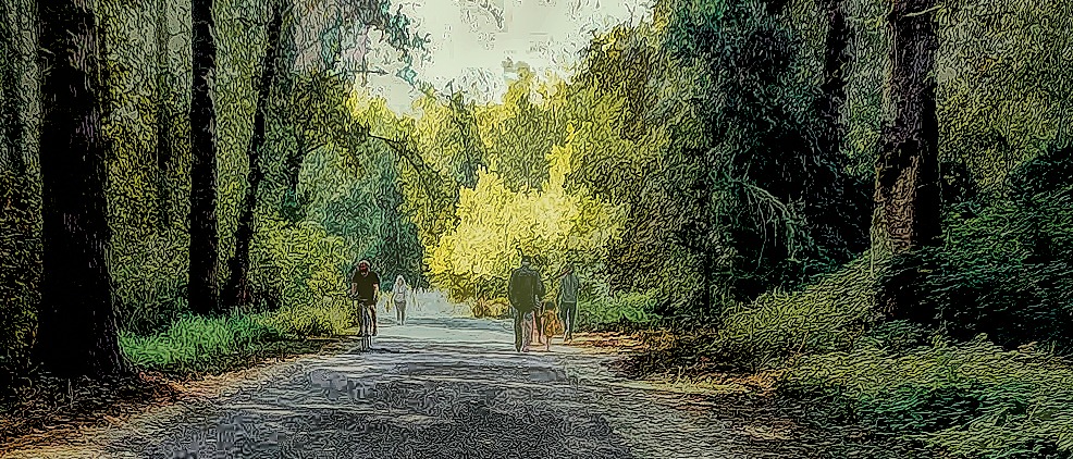
The Sammamish River Trail is the granddaddy of all the trails. It is actually an extension of the 27 mile long Burke-Gilman trail which runs through Seattle from Ballard. The two connect at the Trestle Bridge next to Blythe Park in Bothell although most people don’t realize it. The 10.9 mile long Sammamish River Trail continues on through Woodinville, Kirkland and ends in Redmond at Marymoor Park.


There are a number of places to enter the trail. Blythe Park and Bothell Landing in Bothell are great places to begin. The Wilmot Park in Woodinville works also. The baseball fields in Woodinville and the Sixty Acres soccer fields in the Sammamish Valley also have parking with easy access. Finally, of course, is Marymoor Park. Parking there is a dollar for the day, however.


The trail is completely paved, however it is a busy trail, particularly in the areas near the parks. Walkers and bikers often feel like they are competing for space. Groups of bikers will use the trail to train because of its length. Since this trail is near my home, I walk it nearly every day, but I don’t feel it’s the safest trail as a walker.


In the Bothell area the trail is fairly shaded in places. Once you get past Woodinville, however, the trail is generally sunny. It is also less crowded through the valley so it feels safer. Because it follows the Sammamish River, it can feel more like a nature walk than a city walk as you go through the valley. If you keep your eyes open, you may even see wildlife in the river.


The Cross Kirkland Corridor
The Cross Kirkland Corridor is a 5.75 mile trail that runs from Totem Lake to the South Kirkland Park and Ride. We stumbled across this trail a few years ago in the Totem Lake area. This spring we walked about half of it starting from the Park and Ride.


For many people a walk on the sidewalk along Lake Washington Blvd. is a great summer walk. The sidewalk is near the shore of Lake Washington and its three parks. Unfortunately this popular walk is often crowded and certainly not good for bikes.
Enter the Corridor Trail. This trail is up higher. While there is not a continuous view of the water, there are some really nice views from time to time. The trail is wide but can be crowded in the more central downtown area. Because most of the trail is crushed gravel, there are not many speeding bicycles on the trail. Most of the bikers are kids and families rather than groups training. While parts of the trail feel rural, others definitely are suburban.


One of the interesting aspects of the trail is it goes through the campus of Google. Just north of that there used to be a place that manufactured old fashioned looking camping trailers. Unfortunately it has moved. A little farther north one can find a small park dedicated to the railroad that used to pass through there.


(Update 2024) When we first walked the trail from Totem Lake, we had to cross some very busy intersections. However, a new pedestrian overpass allows walkers and bikers to avoid the traffic and cross with ease. The overpass has a mid-century vibe and also provides nice views to the hidden Totem Lake. It’s a great addition to the trail.


The Cross Kirkland Corridor is intended to be part of a larger trail system called the Eastrail. When the trails are all constructed, there will be 42 miles of connected trail beginning in Renton and going all the way to the town of Snohomish. The Kirkland segment is one of the few sections actually built at this time, and it will be eventually improved to a paved trail.
East Lake Sammamish Trail
If you want to travel farther after completing the aforementioned Sammamish River Trail, then continue on the East Lake Sammamish Trail. This 11 mile trail follows along the east shore of Lake Sammamish from Marymoor Park in Redmond to downtown Issaquah.
At the north end of the trail is a small park, Sammamish Landing. There is a small parking lot here as well as street parking. This provides easy access to the trail which is paved at this section.


Further south the trail is still being developed. A long section of the trail is crushed gravel. When we walked the trail, we started on the trail closer to Issaquah, and walked north about three miles. Most of where we walked was gravel, but toward the end of our walk it became paved.


Much of the trail goes through residential areas so the views were of fences or back yards, some of which were very nice. This segment was not very busy. There were a few bikers but mostly walkers, and most seemed to be from the neighborhood. While it follows along the shore of the lake, the lake is not always visible because of the homes between the trail and the lake.

The biggest challenge with this trail is access. There really aren’t many places to enter the trail. Besides the parking lot at the north end of the trail, there is a small one near the middle of the trail. Further south one could park at Lake Sammamish State Park with a state Discover Pass.
Much like the Kirkland trail, this trail is part of a much larger trail system called the Locks to Lakes Corridor. Connected to the Burk-Gilman and the Sammamish River Trail, it then connects to the Issaquah-Preston Trail for a 44 mile long corridor of trails. This part of the trail is the final link to complete this extensive system of trails.
The Snoqualmie Valley Trail

Continuing further east one reaches the Snoqualmie Valley Trail. This 31 mile trail starts in Duvall, continues through Carnation, Fall City, Snoqualmie, and North Bend ending at Rattlesnake Lake. The trail is mostly crushed gravel and has a rural feel to it. It is fairly flat, but there is a mild incline as you go from Carnation to Snoqualmie.
If you are looking for a trail that’s not too far away, but isolated, this is the trail for you. We walked two segments of the trail. The first was from its beginning in Duvall. There were a few people on the trail within the city limits on a Sunday afternoon, but soon it was mostly just the two of us. The trail travels through the valley here, but the trail itself is usually lined with trees to give some shade.


We started our second section of the trail at Nick Loutsis Park in Carnation and headed south. Again we encountered quite a few people at the beginning of our walk, but within a mile we found ourselves pretty much alone. This section of the trail is more wooded and crosses over the Tolt River as well as some smaller streams. One of them was named Griffin Creek which was funny to me as I attended Griffin Creek Elementary in Oregon as a kid.


With 31 miles to cover, there is certainly plenty of trail that we have not walked. There are a number of places to park and enter the trail. Another section of the trail out of the Snoqualmie Falls area is described in this post.
Well there you have it, four trail options to get you outside and moving. Of course there are many other options around the area. That’s one of the great things about the Seattle area. You don’t really have to travel far to find a place to walk and enjoy being outside.
So where is your favorite place on the Eastside to walk or bike? Do you have a less crowded option you enjoy? Let me know in the comment box below. While you’re at it be sure to subscribe. It’s easy to do.
Discover more from Battered Suitcase
Subscribe to get the latest posts sent to your email.
Well—– It is travel. I have done most of these walks when I drove for Crista Senior community and there is much to see and a a pace chosen by the individual. It is a very wholesome activity. Thanks, Les
Walking is the best way to see things. We walk around in whatever place we go so have to stay fit for when we can travel.