If you have paid much attention to travel news in the last few months, you know this has been a year for road trips. With world travel still closed, and the close quarters of an airplane making people nervous, folks have stayed closer to home. Road trips to the rescue. However, to successfully navigate that road trip one needs a very important element, a map.

Map reading is a skill that has been lost in some ways today. Much like other areas of our lives, we have come to rely on technology to take care of us. I’m not immune; I do the same thing. When we are traveling somewhere new, my wife puts in the address of our destination, and then a voice tells me what road to take and where to turn. I don’t have to read a map. Technology does it for me.
However, sometimes that doesn’t work. When we are overseas we don’t always have access to our phone GPS so that it can tells us where to go. We are also sometimes given maps of historical districts where there are no addresses, just spots on the map, and we have to figure out how to get to them.

Our most recent experience with map frustration was in Australia. There was a store near our hotel that we wanted to visit. When we were in our room, we could see it on Google map in our phone using wi-fi, and it seemed just a few blocks away. However, outside we lost the connection to the map, and we were totally confused for some reason. It took us three tries before we actually ended up at the store.

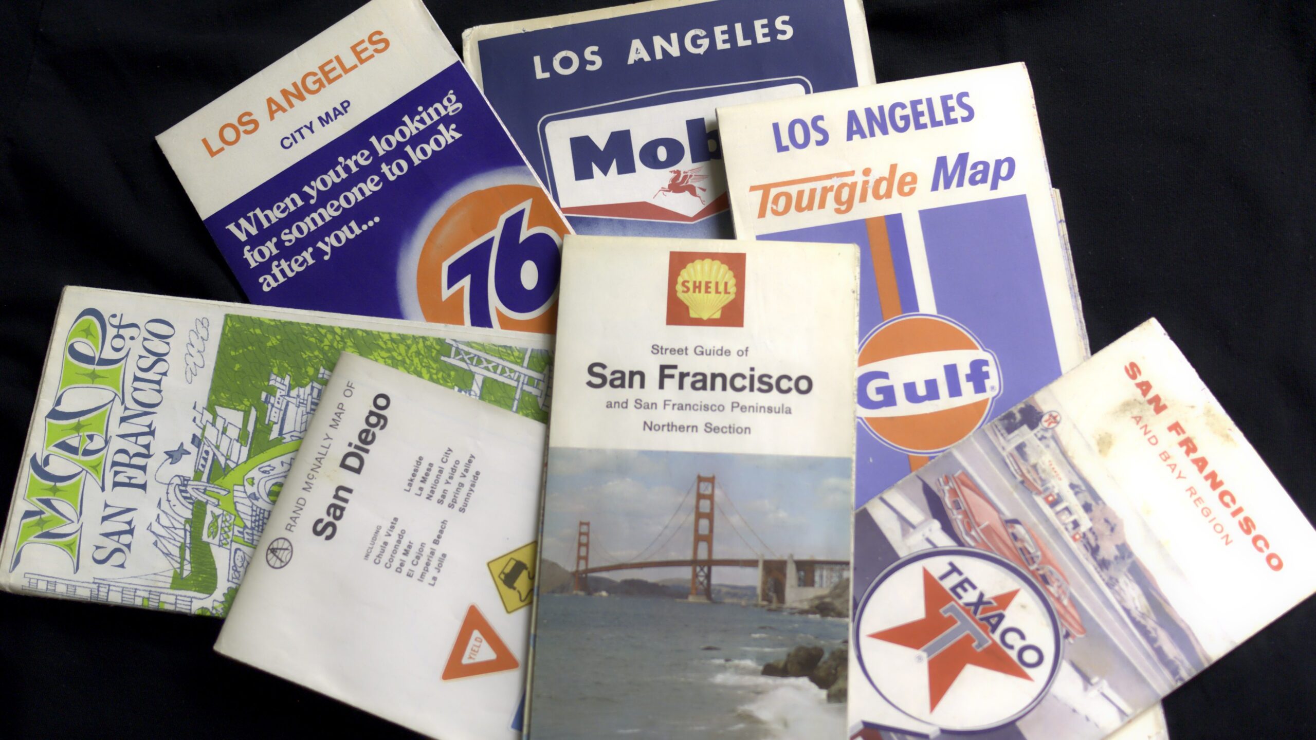
Before the advent of the GPS system, paper maps were very important for travel. Road trips were more common as people didn’t fly as frequently. The good news was those needed maps were easy to come by. Service stations (or gas stations) would have a ready supply of maps to use. They would have one for states, cities, and perhaps even an entire region. For many years they were free, but then they began to sell them for 50 cents or a dollar.
After my father-in-law died, we discovered a collection of maps he had from various oil companies. It was fun to look them over. Often they were not just maps, but were also mini tourist guides. On the back would be information about the state or notes on places to visit or see. They would also usually have scenic pictures of some of the best spots to visit.
The key to reading any map is literally the key. Every map should have a box (the key) that identifies the various elements of the map. These road maps of states actually had quite a bit of information on them if you stopped to take a look.

The first thing in using a map is to figure out the right direction. The good thing about paper maps is that north is almost always up. If there is any uncertainty about that, one could usually find a four point direction indicator that would show the four points of a compass.
Of course once you have everything lined up, it’s just a matter of following the lines. That part is pretty easy until you come to a place where you are changing roads. That can be the tricky part whether you are reading a map or listening to a voice tell you what to do. Entering freeways can be particularly challenging as you may not know which side the entrance will be on. However, long stretches of highway on a road trip are easy to follow.
So what else could a map tell you. Well, the older maps could help you identify how large a city was. Different sized towns would have different colors or types of circles. Usually the capital city of the state would be identified as well.

Maps would also tell you would kind of road you could expect to travel on. Freeways would have a different type of line than a two land highway or a dirt road. This might give you an indication of how fast you would be able to drive on the road.
Another element of maps was they would give mileage between various locations. The cities were points and then a small number would be on the road line to indicate how many miles it was between those two points. Today you can google that information or your map app will tell you. With a paper map you might have to do some quick math in your head if your trip was going to cover quite a distance. Anyone remember mental math exercises?
Today if you want to find a particular town or city, you can plug the name into your map app, and the map will automatically zero in on that location. While that sounds great, I find it sometimes frustrating. What I usually want to know is where that town is in relationship to other towns or where I am at the moment. I want to see the context of the location not the pinpoint on the map. However, when I try to zoom out, I sometimes lose the location, particularly if it is a small town.
On older maps finding a place is quite a bit more work. On the map would be a list of names in tiny print. After the name would be something like B,6. That would indicate on the map the grid area where the town would be found. On the side of the map would be the letter section and at the top the number section. While that narrowed the location down, it still might require some time before one would find the town inside the square indicated, especially if it was a small place. However, once you found the town the location and its relationship to other cities was pretty clear to see.


Of course the biggest challenge with old paper maps was refolding them. Folded maps were always in a long vertical rectangle, and if the map was big, a number of folds would be required. Once unfolded, it seemed that the map folds were hard to match up, and the more well used the map was, the harder it would be to refold. You knew you were successful when you could see the map cover on the front of the map.
Of course there’s one part of a road trip that hasn’t changed much; that’s the interaction between the driver and the map reader. Even with a voice telling you where to go, interaction can happen. I like to have an idea of where I am going so I can plan ahead. Will I need to turn right or left? What lane do I need to be in? Often times the voice on the app doesn’t give me that information soon enough for my liking so I ask the navigator (usually my wife), and depending on the response I get, more discussion may follow. Reminds me of road trips long ago.

How are your map reading skills? Who is the navigator and map reader during your road trips? I’d love to hear about your experiences with maps in the comment section below. In the meantime, enjoy that road trip!
Acknowledgements: The two photos of me with maps were taken by Silvette Lee
Discover more from Battered Suitcase
Subscribe to get the latest posts sent to your email.
Love using maps! My dad was a volunteer firefighter so my first experience was locating house addresses that would come over the scanner. I always had a map when we went on road trips as a kid. Years ago Pam and I started highlighting our road trips in a road atlas. Still one of my favorite possessions! And even with GPS, I still have to have a map when walking through cities and even at amusement parks.
Jeff, sounds like you are the expert. I think maps help give us a sense of place, of where we are. Nobody likes to be lost, but if we can put ourselves on a map, we feel more confident.