After a good night’s sleep and a hearty breakfast at our hotel, we were ready to begin our second day around Death Valley. It was another clear blue-sky day which started out cold, but quickly warmed up with the sun.
Our first experience when we arrived in Death Valley was a drive through the hills on the east side of the Black Mountains. The drive is called Twenty Mule Team Canyon Road. Those of you who are older might be familiar with borax, which was once commonly used as a cleaning product. There was a borax mine in Death Valley. To get the borax out of the valley, they used a team of twenty mules to pull a heavy wagon loaded with borax. The mules became well known, and the 20 mules team became the symbol of the borax industry.
This drive was not a road used by the mule team. However, it does go by areas where miners looked for borax, digging mines into the mountainside. The hills have a variety of colors, but the majority are yellowish in color. The drive is quite narrow in places so it is a one way drive. However, we managed to encounter someone who chose to drive the wrong way. Fortunately we met him in an area that was a little wider. There were other places I’m not sure what we would have done had we encountered him there.
The road is a hard-packed dirt road so it wasn’t too bad of a drive although we scraped something at one point. There are a few places wide enough to stop so you can get out and take a photo. People also hike in the area although there are no designated trails here. We didn’t encounter too many other cars. That allowed us to just stop in the middle of the road to take photos on a few occasions as no one was behind us.


The drive ends just a few miles away from one of the most popular sites in the park, Zabriskie Point. Zabriskie Point has a short but steep climb on a wide paved trail that leads to an observation area over the Golden Canyon and Gower Gulch. It is easy to see why it is named Golden Canyon. Most of the area is composed of the same yellowish color rock that we saw in the Twenty Mule Team Canyon Road.


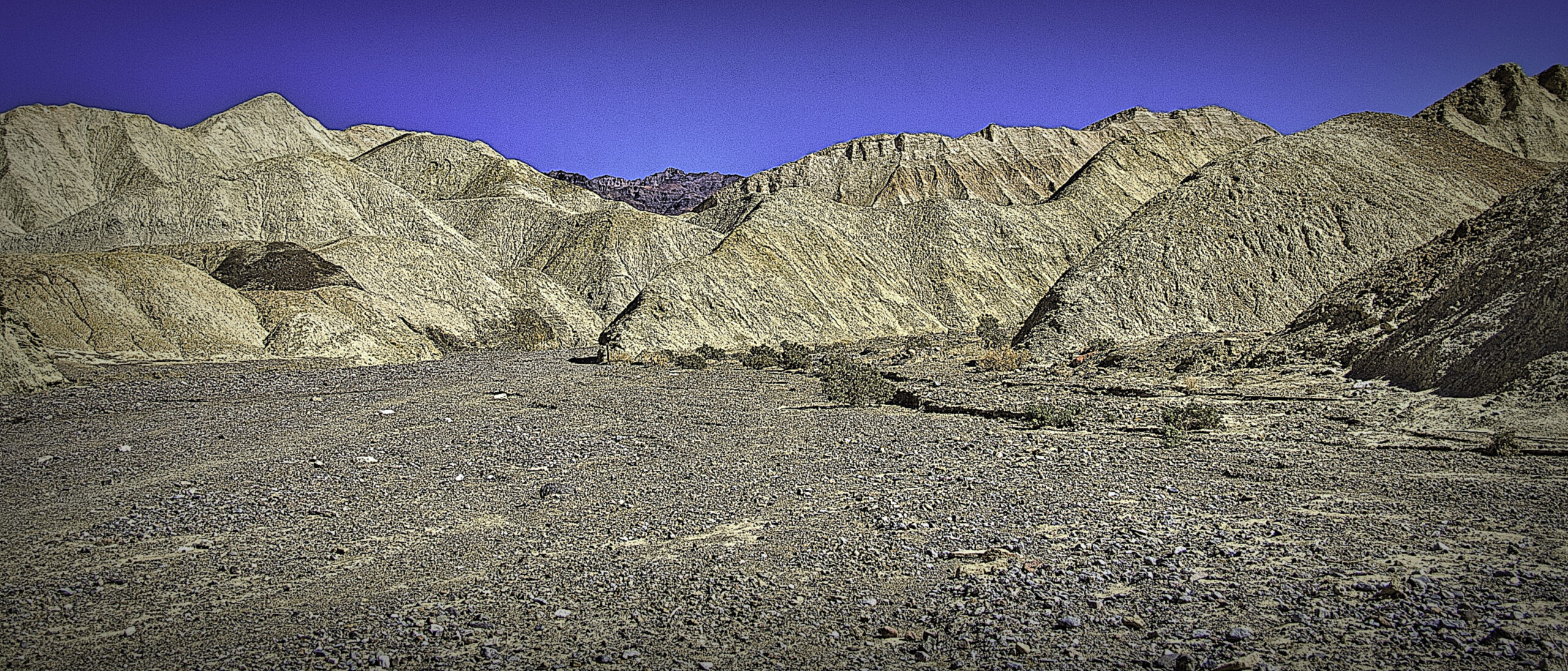
Yesterday as we drove down the other side of the Black Mountains, we saw the sign for Golden Canyon and saw that there was a hike there. We considered doing that hike. However, we noticed on the map a shorter loop hike into the same area near Zabriskie Point. This trail seemed to go in the same area, just from the other side. We decided to go for the shorter hike. Since the sun was already beginning to feel quite warm, we felt it best not to push too much hiking in the sun. There are no trees here to offer shade.
As we began the hike, we started down a wide somewhat gravelly trail. Going down now meant we would need to finish the trail hiking up. It was interesting to be up close and see the rocks and debris that were coming down the ravines created between the various formations. Eventually we came to the area where the trail divided to form the loop. The map suggested that traveling counter clockwise was the best route.


The trail now changed, and we walked in the wide, gravel filled Gower Gulch. While the hills around us were composed of stratified yellowish rock, the gravel had a lot of different colors in them. It was apparent that these rocks were not from the hills around us. I’m not sure where they actually came from.
We walked in the gulch for probably a half mile. It was level and easy to walk. Occasionally we even found some shade from the tall hills around us. While walking we made sure to keep drinking water as the sun was definitely beating down on us.


Eventually we turned right into the hills. I expected the trail to continue low in the valleys and canyons between the hills, but I was wrong. I was surprised to note that we began to climb. It started to get steep, and the trail became more narrow. At that point my wife began to have problems dealing with the height. The trail was too close to the edge for her comfort. It was quite challenging, but eventually we made it back to the junction point of the loop. We finally felt a lot safer and were able to walk out of the canyon. The views on the hike had indeed been amazing, but it was a lot more challenging than I had anticipated.


After finishing up our hike, we stopped at the visitor center to refill our water bottles and eat something. Up until this point we had mostly been in the southern one third of the park. The sites were all in a fairly compact area and were easy to get to. Now we were faced with what to do with the rest of our day. The northern most part of the park was currently closed. Heavy rains had damaged the roads last August so visiting there was not an option. One of the places I wanted to visit on the western side of the park was about 60 miles away. To go and come back would take most of the rest of the day so we decided against that experience.
One of the challenges is that Death Valley is the largest national park in the lower 48 states. It covers about 3000 square miles. From north to south it is about 140 miles so there is a lot of area to cover. As I mentioned, there are a number of well visited sites in the south that are close together. However, the farther north one goes, the more spread out they seem to be.
We finally decided to drive to Stovepipe Wells Village to see what was there. We found an area with camping and some accommodations available. It is somewhat more central to the entire park. We did enjoy an ice cream bar there at the local country store. That seemed a popular item on that day.
With time running short to do any other major hike or visit, we went to the Mesquite Sand Dunes. These are one of the major attractions of the park and are just a few miles from Stovepipe Wells. These are indeed sand dunes as we could see the sparkle of the crystal in the sand. Near the parking lot the dunes are fairly short and well traveled. Many people will just get out and walk a short distance into the dunes, take a selfie, and leave.


I wanted to go back deeper into the dunes. For one reason the dunes were larger the farther away one went. I also wanted to find dunes that were more pristine, meaning they weren’t covered with shoe prints from everyone walking over them. We did walk back a ways, and we saw less footprints. However, I didn’t make it to the largest ones. Climbing the sides of the dunes proved to be more challenging than I expected. It was very much up one side and down the other and then repeat. That was pretty tiring.
So I resorted to pulling out my telephoto lens to get photos of some of the taller, distant dunes. I would have liked to have seen a more complete dune, and not just the tops, but it was the best I could do under the circumstances. I even got people in some of my images who manged to walk back farther than I was able to walk.
The space in between the dunes was not always sand. In one section it was a dried mud area with lots of cracks. In another area the sand was lighter than the surrounding dunes. From almost all angles one could see the mountains in the background. It all combined to create interesting views.


With that it was back to the car, dump the sand out of our shoes, and head back to our hotel. After our hike in the morning, it felt like a full, tiring day even though we didn’t see as many things on this day as we had the day before. Unfortunately we would leave many places still unseen. While I would say we did manage to see the highlights of the park, there are still plenty of other locations we did not see. I don’t know if we will ever make it back to Death Valley, but I was intrigued by what we did see. It was definitely worth the visit.
Have you ever visited Death Valley? Did you see something we missed on our trip. I’d love to hear about it in the comment section below. Be sure to like, share or subscribe if you haven’t already. It’s helpful to know what my readers are thinking.
Discover more from Battered Suitcase
Subscribe to get the latest posts sent to your email.
Love this. I never made it to death valley but when I was young we travelled all over and sand dunes are a challenge I think.
I’m used to the sand dunes along the coast so these seemed different. Thanks for you comment.
I have not seen Death Vally. Great pictures. Thanks for sharing.
Thanks, Les. Death Valley has a most unique landscape. I enjoyed it.