Deception Pass is the narrow strait between Fidalgo Island and Whidbey Island about an hour north of Seattle. It was named by George Vancouver after apparently neither he nor his crew noticed it on their first exploration to the area. Later, when they did discover it, they thought it had deceived them, thus the name.
Today this strait is traversed by bridges. Between the two large islands is another small island, Pass Island, so there are actually two bridges. They connect on Pass Island although you barely realize it as you drive over it. The bridge was completed in 1935. If you are wanting to explore Whidbey Island, this is the long way around from Seattle. The shorter route is to take the ferry from Mukilteo.
Surrounding the strait is Deception Pass State Park. This can be a good place to hike in the winter months to avoid the mountain snow. The park has a number of places to explore. Do note that as a state park there is a parking fee of $10 or you need a yearly Discover Pass for $30 which is good at all the Washington State parks.
Coming from the Fidalgo Island side there is a road on the right just before the bridge that takes you down to two different parking areas. The first one is the larger one, Bowman Bay. There is a fairly large parking lot here along with picnic tables and a long beach. Around the picnic area are nice grassy areas. Further back is a campground for overnight tent camping. There is also a center to learn about the Civilian Conservation Corp and its role in developing parks.


The second parking area, Rosario Head, is a little further down the road. There are not as many parking spaces here, but it does have picnic tables and nice restroom facilities. This is where we parked on a recent visit. The beach is not as wide here. The head itself is a large point out into the strait.
We began our exploration by walking back along a trail to Bowman Bay and from there over to Reservation Head. This is a fairly easy walk although coming into Bowman Bay is a bit steep. The trail goes along the bank and there are a lot of nice views from here. In places there are actually two trails, one closer to the cliff and water and the other one wider and farther from the edge.


At Bowman Bay the beach is walkable or one can just walk through the picnic area which is what we did. On the other side of the bay near the main parking lot is a long dock, but it was closed off. I presume that’s just for the winter. At that point the trail begins to become more obvious again heading out to Reservation Head.


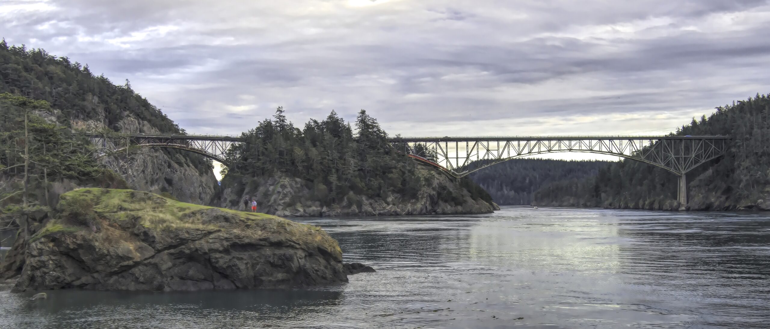
Once you leave the beach area, there is a fairly steep but short hill to get over. It seemed a little muddy and slippery to us so we took it slowly, but we were able to manage. The trail then comes back down to water level. Not far down the trail there is a choice. One can continue straight which goes out to a point where the bridges are visible. The other trail crosses over a narrow beach area to Reservation Head. Initially we went straight, but everyone seemed to be going the other way so we doubled back.


Reservation head is a fairly large piece of land jutting out into Deception Pass. The trail is easy to follow and will lead hikers to a viewpoint of the bridges and the strait. There are some interesting rock formations here as well. This is definitely a picture spot.


From this location we continued walking around the head. There are a number of viewpoints. Some look back towards the bridge. Others look across the water to the other side of Deception Pass, while others look out toward Puget Sound and the Olympic Mountains. Depending on the weather and the time of day there are a lot of pictures to be had here. The trail continues around and eventually we arrived back at the main trail returning us to Bowman Bay.


We took the same trail back to Rosario Head through Bowman Bay. When we arrived back at Rosario Head we were going to go out to the point there, but there was a sign indicating caution was needed so we chose not to go there as it was getting dark. However, we did see the wood carved statue entitled The Maiden of Deception Pass. It depicts a native American woman holding up a salmon.
Since the sun was beginning to set we stuck around to enjoy the sunset. We first went up on some rocks, but it was higher up than I wanted so I went down to the beach. From there a number of large rocks jutting out of the water added to the interest of the sunset. It tuned out to be a beautiful sunset and a great way to end our visit.


Have you visited Deception Pass? What was your experience there? Please share your thoughts and suggestions in the box below, and don’t forget to sign up for the weekly post delivered directly into your email each Wednesday. Next week we will look at the south side of the park.
Discover more from Battered Suitcase
Subscribe to get the latest posts sent to your email.
In the last group of pictures, there’s one showing some buildings. Is that a town?
It’s not a town; it seems to be just a community. I’m not sure if it’s private or not. There is a place named Rosario Beach Marine Laboratory next to the park owned by Walla Walla University which has some cabins. I’m not sure if the homes are owned by them or not.
Gorgeous photos!
Thanks, Nate, I appreciate your comment.
I admire your energy to take the walk. Also excellent pictures. I have not been through the pass on a boat but have been on the bridge at high tide. One can see the challenge of people on boats passing through would be a challenge. I have been there several times. Always a positive experience.
Les, thanks for your comments. I have never gone through on a boat either. There are plenty of great views from the shoreline.