Our main reason for coming to Canada was to spend time with my brother and his wife in Whistler. After a few days in North Vancouver we were ready to head farther north. Sadly Tuesday dawned cold and dreary again. While it didn’t rain much, the clouds hung low in the sky.
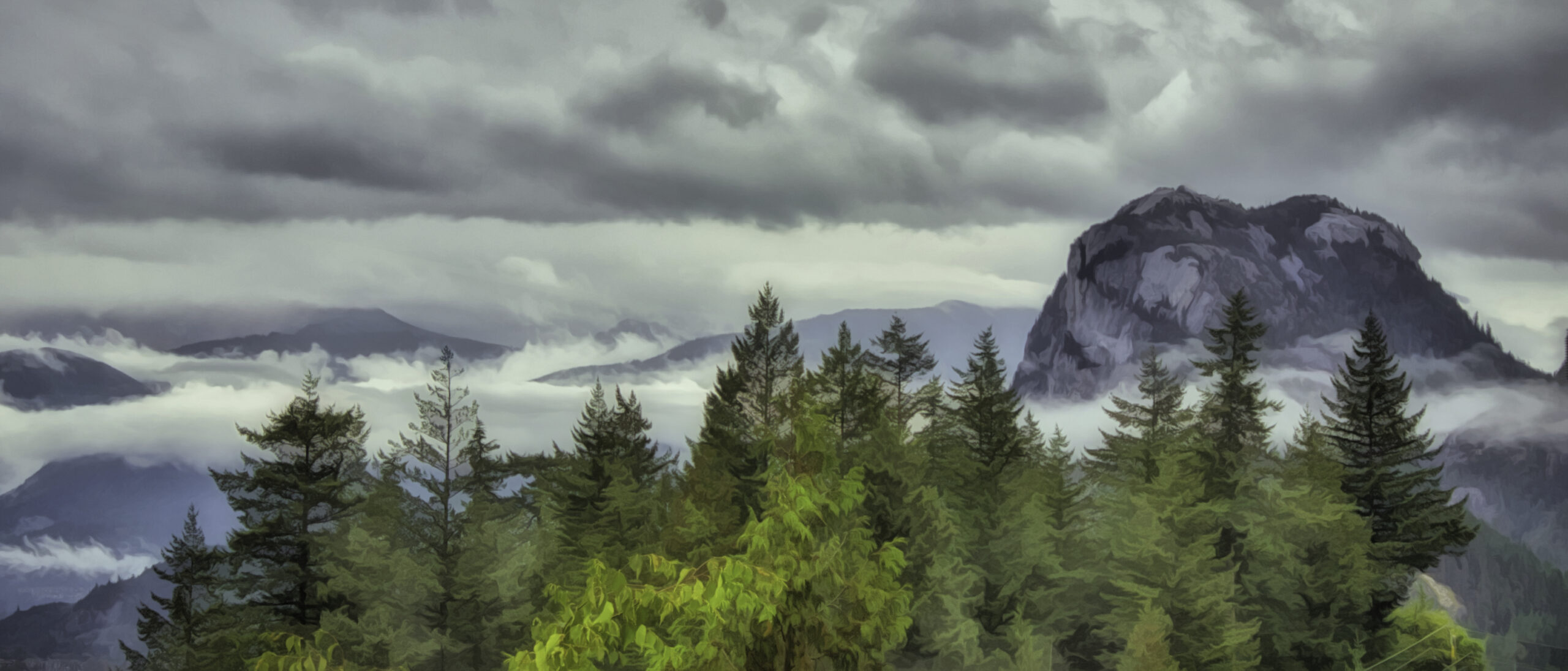
The first part of the drive to Whistler is along Howe Sound which later changes to Squamish Harbor. I had hoped to take some photos along the way, but that didn’t work out well. First I had trouble finding any place to stop and take a photo. There didn’t seem to be any viewpoints, and I was unsure where I would end up if I got off the highway. The clouds hanging low over the mountains created interesting images, but they also obscured parts of the mountains.
I finally stopped at a gravel space on the side of the road as we neared the town of Squamish. A little bit farther ahead I turned off down a road. It turns out there was an old ferry terminal there which was no longer in use. The water in this area was a milky green color which seems to be from the glacial runoff. I was able to get a few photos of the area and some of the mountains across the way.


We also stopped in Squamish which is at the end of the harbor, but I couldn’t seem to find my way down to the water so I gave up looking. Farther along the highway we did encounter a viewpoint. We stopped, but the clouds pretty much obscured the mountains so there wasn’t much to photograph.
After two days in Whistler, we were ready to return the way we came. The day of our return, Friday, turned out to be a sunny, beautiful day with no clouds in the sky. Definitely a better day although the moody low clouds of Tuesday had their charm. We left about 11:00 heading back towards Vancouver. Not too far down the road from Whistler I saw a sign for a lake so I decided to check it out. The road wasn’t that great, and it was a lot longer drive than I anticipated. When we finally came to a parking lot, it was completely full, and I didn’t see a lake anywhere. I figured we would have to hike to it, and I didn’t think we had enough time so we just left.
We did stop by a river as we got closer to Squamish. Conroy Creek has a bit of that milky color to it which I find so interesting. However, when we stopped, what was fascinating was some kind of equipment on the other side of the creek. I guessed it was an old ski lift, but I couldn’t be sure.


There was one other popular viewpoint before we got to Squamish. The main scenic point was the distant snow capped mountains. Since it was late in the summer, the snow or glaciers seemed somewhat limited, but it was still a nice vista. This stop also provided information about the First Nations people who lived in the area. Visitors can read about various aspects of the native culture along with viewing some old photographs.


When we finally got to Squamish, I wanted to try again to walk out to the harbor. After driving around a bit we did find a trail that lead in the direction of the Squamish Harbor along a waterway. We walked it for a bit, but then realized that it was going to be farther than we thought. Time constraints again caused us to stop and not continue on to the water.


I was feeling a little discouraged about getting photos of the water. We stopped at the same spot we had stopped at just beyond the town of Squamish. Without the clouds there was definitely a difference in the scenery, but the trees still limited the views. You can compare these photos to the ones in the first set above.


A little farther down the road was a sign for a viewpoint. I stopped, but again trees partially blocked the views. There was information here about a nearby mine which seemed a little odd as there was no mine at that location.

At the next stop we finally found the views I was looking for. Porteau Cove is a nice park with lots of parking. It looked like it was another old ferry terminal that is no longer in use. There were beaches on both sides of the parking area. However, the more interesting part was the viewpoints that had been created along the wharf leading out to the ferry. These were built up high so they provided good views of the area.
Of course from a photographer’s point of view a bright, sunny day is not the best for taking pictures. The contrast of bright light with shadows makes it difficult to see details, but as travelers, options are limited so one takes what one can get.


There was one more viewpoint we stopped at. Again the view was limited by the trees growing. The major attraction at this point seemed to be a statue of a First Nations woman. There was also information about the tribes in this area.


Shortly after leaving this viewpoint, we began to get into Vancouver traffic. On a Friday afternoon, traffic was tricky, but we eventually made it through and drove down to the border. Our wait at the border wasn’t too bad. After crossing the border, we stopped in the town of Blaine.
Blaine is a small town that overlooks the water. It was actually more interesting than we expected. We had dinner here and then continued our journey home.
The water views along Howe Sound are quite beautiful. I only wish there were more and better opportunities to take photos of this majestic area. In the future I hope to have another chance to photograph here. Maybe some day I’ll get the magical moment with perfect lighting. In the meantime it’s on to the next adventure. See you next week in Whistler, BC.
Discover more from Battered Suitcase
Subscribe to get the latest posts sent to your email.
Yes. It is a beautiful drive.
It sounds like you have driven it before. I hope you had nice weather. Thanks for commenting
I visited Whistler a couple of times years and years ago. I’m sure it’s grown exponentially since then, but it was all new and wonderful.
Yes, we last visited probably thirty years ago and things have definitely changed. It is a nice place to get away from it all, I’ll be sharing more in the next few weeks.