The Olympic Peninsula is a large part of the state of Washington. However, we had never taken the opportunity to really explore it. We have visited a few areas, but never spent a lot of time in the region. This year as we approached fall, we wanted to get some more traveling in. However, all of our original ideas fell away as COVID seemed to be everywhere, and we didn’t want to take too much risk traveling. Finally we concluded a road trip would be our safest option, and the Olympic Peninsula became our destination. We would finally explore this region of our state.
To get to the Olympic Peninsula we crossed Puget Sound on the ferry from Edmonds to Kingston. From Kingston we traveled through Port Gamble to get to the Hood Canal Bridge that crosses to the peninsula. While Port Gamble is an interesting old mill town with older style homes, we have visited it before so we didn’t stop this time.


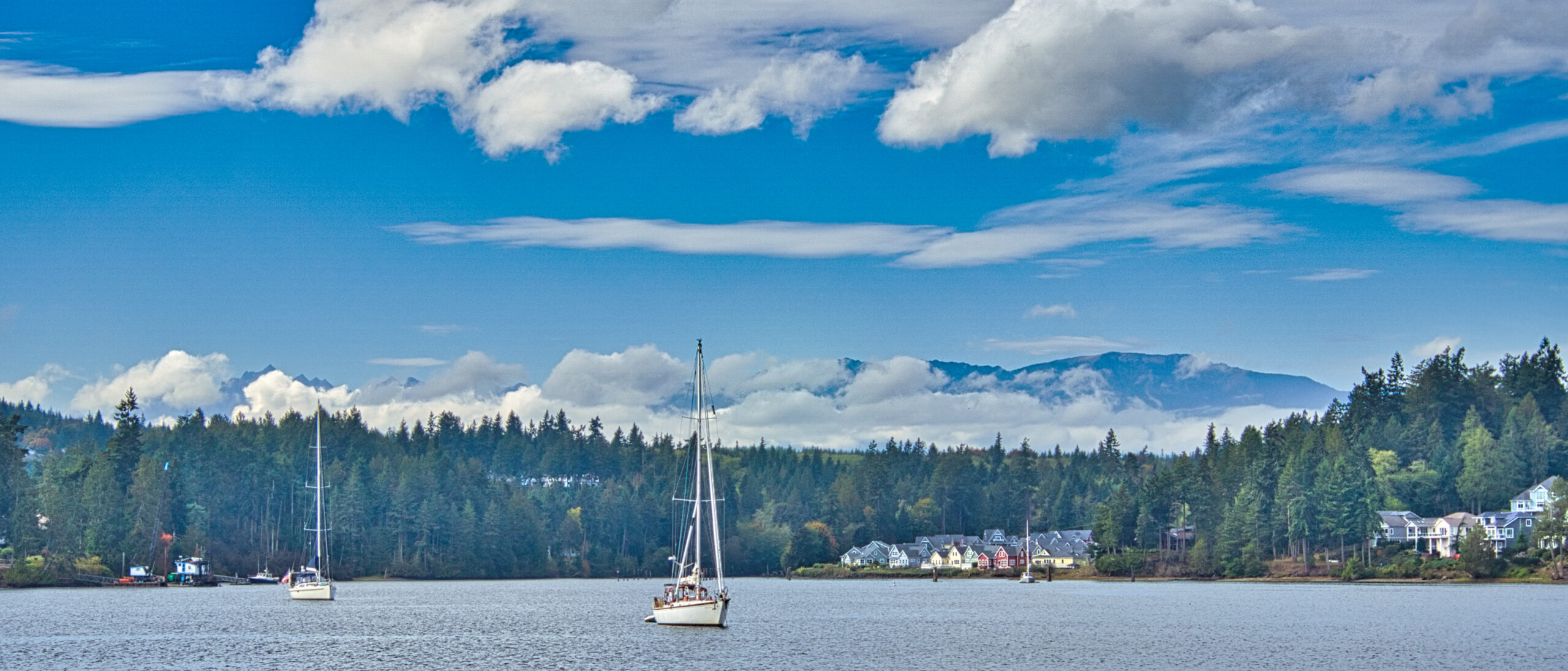
Our first stop was a town we had never visited before, Port Ludlow. After leaving Highway 19, we drove down to the Port Ludlow Marina. Near the marina sits the Port Ludlow Inn which was designed to resemble a New England style Inn. It is a very beautiful location. If one looks west, the Olympic mountains are visible in the background when the clouds aren’t hiding them. Near the inn we found a loop walk that goes along the beach and then back around to the marina. It also passes a large totem pole on one end and the busy pickle ball courts on the other end. It’s only a half mile walk and quite scenic as we found Port Ludlow to be a picturesque inlet.


From the Port Ludlow Marina, we drove back up by the major shopping area. Our destination was another half mile loop walk. This time the walk was a peaceful excursion through a forest and along a creek to Ludlow Falls. What I found interesting was that the information piece near the falls talked about the river cutting through basalt, something that I saw a lot of recently in Iceland.


Leaving Port Ludlow behind, we headed to Fort Flagler. The US government had built three forts to protect the entrance to Puget Sound. One is Fort Casey on Whidbey Island. I have been to that particular fort a number of times as it is next to a camp owned by my alma mater, Seattle Pacific University. The other two forts, Fort Flagler and Fort Worden, are on the peninsula. Together these were known as “The Triangle of Fire.” We had never been to either of the ones on the peninsula so this was the perfect opportunity to visit these now state parks.
Fort Flagler is on Marrowstone Island. To get to Marrowstone Island one has to cross Indian Island. A large Naval facility takes up much of Indian Island, but there are parks along the southern edge of the island. These parks allow access to the beach, the cliffs, and the area between the islands.


Fort Flagler is a large park on the northern end of Marrowstone Island. We started our exploration by going down toward the water and wandering along the beach. At one point we saw some sea life and wondered what it was. Someone told us they were steller sea lions. Unfortunately we could only see their fins sticking out of the water. However we did enjoy watching some of the more visible birds in the area.
In walking along the coast, we came across a round cement area that looked like perhaps it had been the base of some kind of canon. Within the circle we saw an unexpected art piece which seemed to celebrate the natural elements in the area. It was really interesting to see this art on a piece of old military concrete. Of course we don’t know exactly when it was placed there.


Driving back up to the main area we saw a large field with housing options around it. Apparently families can rent some houses while others are available for retreat groups. In the large center field a herd of deer were wandering around, eating, and resting. We actually saw quite a few deer on this day. Many were right next to the road which made me nervous as I was afraid they would dart out into the road in front of me.
In another section of the park, we saw two old guns with the bunkers below where they stored the ammunition. There were some other areas of the park which we didn’t check out in the interest of time. However we were able to enjoy the beautiful warm, sunny weather which made for a pleasant afternoon visit.


On the way back to Highway 19, we made a quick stop at Mystery Bay State Park. It is a beautiful little park right on Mystery Bay. It’s basically more of a place for launching boats, but there are some picnic tables along the waterfront.


From Marrowstone Island we headed for Port Townsend which is known for its interesting architecture. It has become a popular destination for a weekend or even a day trip. It was quite busy the Saturday we visited. We had stopped here mainly to find something to eat, but that turned out to be more of a challenge than we expected. The COVID rules in the area are pretty strict, and a number of restaurants were closed. Others were doing take out only. We finally found a good take out pizza and ate it at some outside tables near the water. Thankfully the weather wasn’t too bad.


After eating we were then off to our final site of the day, Fort Worden. Unfortunately it was getting late at this point so we weren’t able to explore the park as much as we would have liked. Near the entrance area there seemed to be a lot of housing options. Here again, one can rent out a place to stay for a family or a group.
For those staying at the park, it has a number of interesting places to check out including an aquarium and a military museum. When we arrived, we again chose to drive down to the beach area. We walked out to the aquarium on a wharf and had great views from there. We saw the colorful sunset over the Cascades which was a little strange as we were actually looking east. However, the clouds were blocking most of the light looking west, but were less dense over the mountains. This allowed the sunlight to hit the mountains creating an orange glow. We could even see Mt. Rainier which was an unexpected scenic view.
For our final adventure we drove just a bit farther down to a light house. It was next to the beach, and the waves were really crashing in this area. Unfortunately the lighthouse had seen better days. There was a residence next to it which one can also apparently rent out.
Sadly it was getting too dark to be able to see much more. I was disappointed we had not seen the artillery areas, but that just means we will have to come back at a later date to do some more exploration of the park.


As the sun disappeared, we finally headed for our motel in Port Angeles. It was a bit of a drive, but we were using Port Angeles as our base of travel for the next few days. We were anticipating discovering more of this beautiful part of our state the next day.
Have you had the opportunity to visit this part of the Olympic Peninsula? What is your favorite area? Share your thoughts in the comment section below. I always enjoy reading your stories.
Discover more from Battered Suitcase
Subscribe to get the latest posts sent to your email.
Loved all of the phots. Some seem like they are not real places. Beautiful
Janie, thanks so much for your comment. I have been working on improving my photos. I’m glad you are enjoying them.
Hurricane Ridge has always been one of favorite places to visit. Keep posting your pictures, Steve.
Thanks, Gene, Hurricane Ridge is up next week. Check back then.
Great photography, also lots of beauty and natural settings so close to home. Good choice.
Thanks, Les, it’s interesting how we often miss what is closest to us. Stayed tuned. Next week we go above the clouds.
Pam and I camped at Fort Flagler last year. Really nice park. On our way home we drove past Port Ludlow. Had never been. We have recently taken up playing pickle ball so now you’ve made me think that maybe we need to go stay there sometime! 🙂
Thanks for sharing. The pickle ball courts were all full when we walked by. It seemed very popular.