On Sunday we spent a lot of time walking, especially through the Garden of the Gods. By contrast Monday we spent a lot of time driving. It started with a drive up Pikes Peak and ended nearly 200 hundred miles south in Alamosa, Colorado
We started with Pikes Peak. Colorado refers to it as America’s mountain. Ever since I was a kid, I have heard of Pikes Peak. Therefore when we planned this trip, and I realized we would be near it, I knew I had to go up. However, we arrived on a snowy day, and the following day the mountain was covered in clouds. I knew weather had an impact on whether people could go up the mountain or not so I wasn’t sure what would happen.
Fortunately Monday dawned a glorious clear day with no clouds covering Pikes Peak. I checked, and people were being allowed to drive up, but only the first 13 miles. No one could go to the peak. While that was a disappointment, I knew I still wanted to drive up as far as I could.

We arrived at the entrance to the drive, paid our entrance fee, and then the woman surprisingly explained to me about our rental car. The staff encourages drivers to come down Pikes Peak in low gear so as not to burn out their brakes. My rental was a hybrid with some unique qualities about gears. She was able to explain it to me, and it ended up being very helpful.
I expected the drive up to be sort of on the edge of the mountain, but there were only a few places where we were really driving on the edge. One place was quite near the beginning, then we moved more into forested areas.
The first place we stopped was at Crystal Reservoir. This is the only visitor center open at the time since the summit was closed. The reservoir collects water for the city of Colorado Springs. It is actually a pretty lake. From this location the water and the high mountains above it form beautiful images. We walked down to the water’s edge a little ways. There was still snow on the ground in places at this elevation.


We continued our climb up the mountain and stopped at a parking lot where I grabbed a few photos. Our next stop was at a large picnic area. Here the snow pretty much covered everything. People were stopping here as the bathrooms were open. I wanted to check farther back to see if there was a view. I trudged through the snow and eventually came to a place where I did get a bit of a view. However, I also got into some pretty deep snow at times. At one point it was almost up to my knees. I was also a bit disoriented and ended up coming out to the main road quite a distance from the car.
I did get a fun picture here. In the restroom I saw a dripping icicle and shot a bunch of photos with the drop of water coming off the icicle. I think this is the best one.


At this point we were getting pretty high up. As the road turned, we lost sight of Pikes Peak and never saw it again as we continued up. However, some of the other nearby mountain peaks remained visible.


As we approached mile 13, we came to a general store, but it was closed, We thought we would have to stop there, but a sign indicated we could go farther. Sadly it wasn’t much farther. The road was blocked off, and a ranger was there making sure no one went farther than they were allowed. The road looked mostly clear beyond the barricade, but there was no going ahead.
At one point I thought I saw an avalanche as it looked like snow was coming down the hill. However, a local told me it was a snow blower on the road above who was shooting snow into the air to get it off the road. It looked cool however,


We eventually started back down stopping a few places for photos. I was especially trying to get photos of the reservoir and another lake I could see from above.
Since we didn’t make it to the summit, I was a little disappointed with the experience, but since I doubt we will go back, this was the time to go.


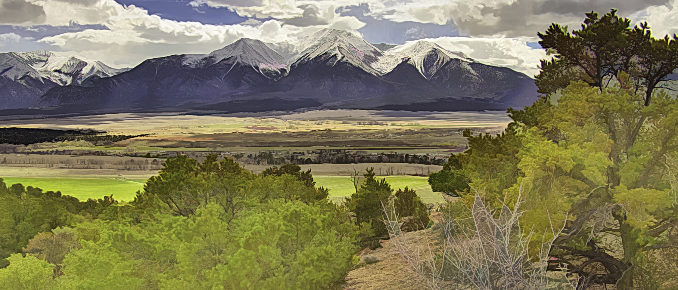
Once back down we began our long trek to Alamosa, which is near Great Sand Dunes National Park, our destination for Tuesday. For the first part of the trip Silvette drove west over the mountains while I took a nap so I can’t tell you much about that area. However, as we came down the mountains, straight ahead we saw a large range of snow capped mountains, the Sawatch Range. The mountains seemed to rise from the valley floor so the sight was impressive. We stopped at an overlook to get a better view and to learn what we could about the mountains.
The overlook has a number of trails along the ridge so we did a little bit of hiking, but didn’t go too far. We did learn about the mountains and saw pictures with all their names laid out to see. The range includes some of the tallest peaks in Colorado. They really were beautiful with the snow on them. We also got a glimpse of the Arkansas River just south of the overlook.


We now turned south and decided to stop at Browns Canyon National Monument and do a little hike as we had been sitting for too long. (If you don’t know what a National Monument is, click here) There are two entrances, and we planned to go to the southern entrance. However, even though we saw the sign, we drove past it as it is a pretty inconspicuous road. The road was unpaved and quite twisty, but we finally made it to our destination, the Arkansas River which flows through the canyon.
I had read about a short two mile round trip hike along the river that was pretty easy. The problem was we couldn’t find it. We looked for signs, but nothing. We finally went up to a camping area thinking the trail was there. However, the trails we found were very difficult and didn’t seem to go very far.


We were about to give up and leave when I tried going in the opposite direction along the river, and there was the trail. Although it was getting late, I persuaded Silvette to go a little ways along the trail. There were some rocky areas, but it wasn’t too bad of a trail and had some nice views of the river. This is a very rugged area so it has interesting rock formations to view. On the other side of the river is an old railroad line still visible.


Back in the car we made it out to the main road without incident and continued the still long trip south. We did have another snowcapped mountain range appear on the other side of the valley, but I never found any information about it. The biggest challenge was the road was straight and loooooong. It was so boring to drive. There were no curves. It was straight for miles. It ran through a wide valley. In some places we saw agricultural acivity, but in others it was mostly sagebrush. I was happy to reach our destination in Alamosa just before the sun set.
Next week read about our experience at Great Sand Dunes National Park. If you enjoy it, share it with a friend. Don’t forget to share your experiences visiting Pikes Peak or driving in Colorado in the comment box below. Above all, keep traveling.
Credit: Photo of Pikes Peak entrance by Silvette Lee
Discover more from Battered Suitcase
Subscribe to get the latest posts sent to your email.