Monday’s weather was cooler than Sunday’s. There was also a prediction for a thunderstorm in the afternoon. With that in mind we dressed for the anticipated weather and headed off for Capitol Reef National Park. I read online that the park was undergoing some construction projects and parts of the park were closed. I wasn’t sure how that would impact our day.
This park does not have a pay booth as one enters because part of the park is just off of a major highway. We bypassed some of the initial stops as we wanted to check out our options at the Visitor Center. We arrived there and faced our first challenge with construction. The parking lot had limited parking. Fortunately we were able to get a spot from someone who was just leaving.
With some information in hand, we left the Visitor Center to begin exploring. Part of this park offers an historical perspective of the region. Some Mormon families had settled in the valley of the Fremont River. Some of the elements of their farming is still seen and available to check out. Our first stop was at the blacksmith shop where we had a peek inside.


I wanted to follow a trail that went along the Fremont River. A large park across from the blacksmith shop seemed to be the spot to begin. Unfortunately the bridge crossing the river did not lead to a trail. It did, however, offer some beautiful views of the nearby cliffs. We also saw the apparently resident deer herd as posted signs indicated not to feed them.


We drove over to the Gifford House. This was the home for one of the families who had lived in the area. Today it is a combination museum and store although I would say more store. Only one room seemed set up only to display antique items. The rest had home merchandise for sale. However, the biggest sellers were small pies. They could feed two for $8.50. Fruit pies were a nod to the fruit trees in the area. Capital Reef has about 2000 fruit trees, and when the fruits ripen, park visitors can pick and eat the fruit. The park charges those who take fruit with them out of the park.


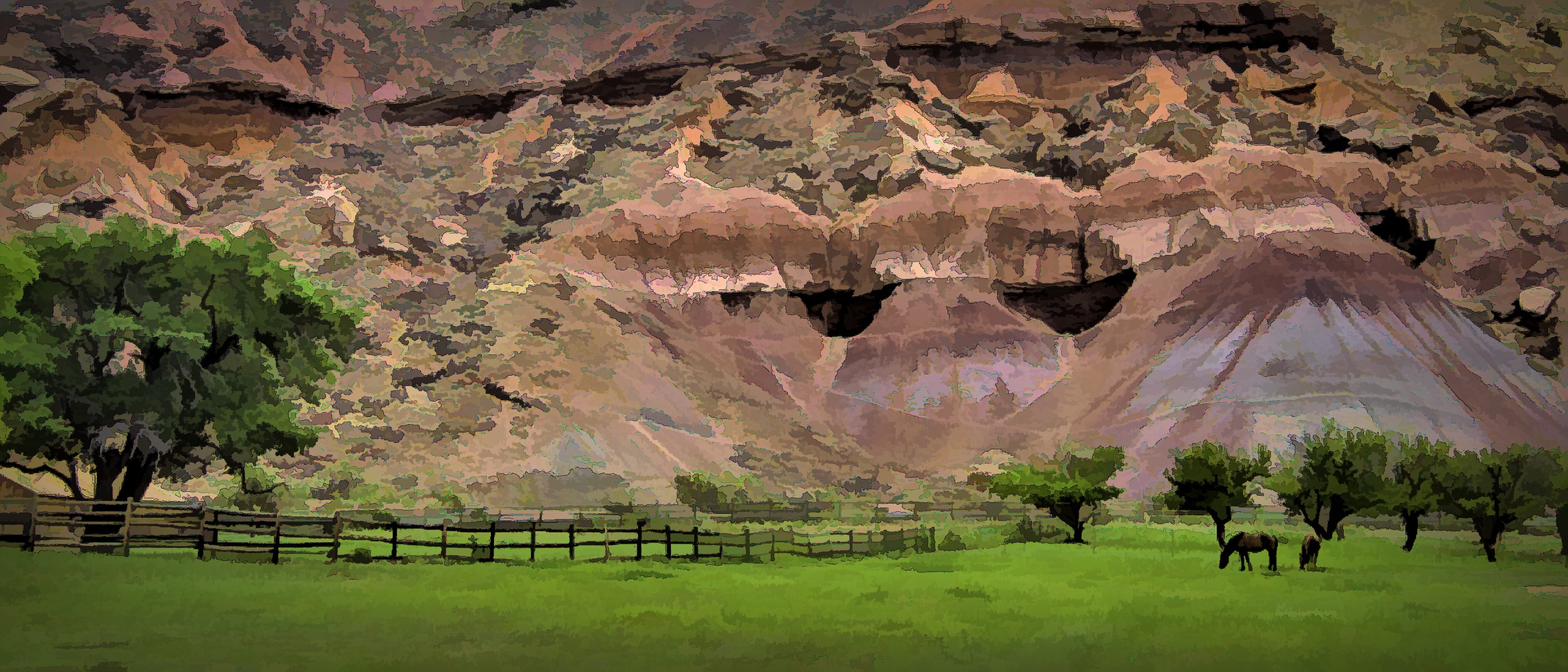
After visiting the Gifford House, we found the Fremont River trail I had been looking for. It was a fairly easy walk along the river. The unfortunate things was the river was only visible occasionally. Tall shrubs hid the river most of the time. However, we could hear it, and it was a soothing sound. On the other side of the trail we passed a pasture with some horses as well as some orchards.


The park guide listed the trail as a moderate hike with a rather steep ending to a view point. That was true as far as it went. It did have a steep ending. Unfortunately it was also on the side of the cliff. As soon as we approached it, I knew we were not going to the top. I walked partway up the trail to see over the shrubs and get a better view of the valley. Then we turned around and walked back towards our car.


Next to the Gifford House was a picnic area. It was actually a pretty popular spot. I think the pies added to its popularity as I saw a number of people eating their pies there. While we didn’t have pie, we did have some lunch we brought. We enjoyed it while sitting under a shady tree.

Fortified we continued on to the Scenic Route. This was a drive through Capitol Reef, but was the main place that was closed for construction. The park was adding to the parking lots of the various stops as well as widening the roads. I didn’t know how far I could drive before I had to stop so we kept driving. Eventually we came to the first main visitor stop on the road which was Grand Wash Road. We were following some other cars so we followed them down the road. It was a dirt road and somewhat bumpy, but we kept going and going, much farther than I expected. Eventually we came to a parking lot and a trailhead the Grand Wash Trail. Again we got lucky and pulled in where someone was leaving.
We looked at the information on the hike and decided we would do it, at least partially. It was rated easy, but was also 2.2 miles one way. We weren’t sure if we were up for the nearly four and a half mile round trip. Nevertheless, I got my walking sticks out, and we began the hike.
It turned out to be a fairly easy hike as most of it was on a very wide trail, a wash, and it was pretty flat. I thought there was a gradual downward grade to the trail, but it was very slight. The trail went through tall cliffs of rock. While there were some areas of red rock, many of the cliffs on this walk were not red rock. Often the cliffs were solid rock. They were not layered, just solid, flat rock.


We eventually came to a place where the space was kind of open. I decided to use my phone to make a 360 degree video of our location. The video shows the various walls and formations surrounding us.
We continued on in this wider part of the trail. At one point Silvette turned back to get my attention. A small mountain goat was walking down the trail. By the time I was close enough for a photo, it had gone up on the side of the trail with its tail to me. Nevertheless it was fun to see.


The Grand Wash trail turned, and the rock walls began to narrow into each other. They call this part of the trial the Narrows. It is actually amazing to be surrounded by such tall rock cliffs. It was a little bit like our walk down in Bryce Canyon, except we didn’t need to walk down and back up. That made it much easier.


We walked a little farther after the narrow canyon section. We had walked 1.75 miles and wondered if maybe we should turn back. Some young men indicated to us that we had gone through the most interesting part of the trail so that encouraged us to head back. It had also become hot. The clouds had gone away, and the sun was shining directly on us. We wondered what happened to our cool day.
Fortunately the clouds did come back as we did the last half mile or so of our hike. I didn’t take as many pictures walking back as I did going in, but there were a few new scenes worth shooting.


Back in the car we headed back toward Capitol Reef Visitor Center. I got a photo of the cliffs as we drove out of the Great Wash.

It was 4:00, and we decided we would head back to our motel and stop at some of the scenic spots we had passed by on our way in this morning. The first stop was for some of the rock features along the side of the highway aptly named the Fluted Wall. One can guess why.


Our next stop was a rather unexpected experience. The map showed two locations. The first one we came to had no available parking, so I decided to continue on to the second spot. The unpaved road in places had a washboard effect on the road. It really rattled the car as we drove over it. We did make it to the stop, and we were able to look down into the canyon created by Sulpher Creek. The area was called the Goosenecks Overlook. Gooseneck is the name given to the sharp turns and curves created by the creek in the canyon.


From this location we could also look back at the large formations of Capitol Reef close to the main road. We were up so high that we had a good vantage point to see quite a distance. Going back down we didn’t see a need to stop at the other viewpoint as it was lower, and we had seen all they could see.


We had one more stop to make. The formation was called Chimney Rock. I’m sure you can figure out why. One other formation in the area also seemed worthy of a picture.


We stopped for dinner at a Mexican restaurant on our way back to our motel. Then we settled in after a tiring day of hiking. Tomorrow will be a travel day back to Nevada. It’s a pretty long drive which we are not looking forward to. Check back next week to see how we fared.
We certainly didn’t see all there is to see at Capitol Reef. If you have visited there, I would love to have you share your experience in the comment box below. Thanks for your interest and support.
Discover more from Battered Suitcase
Subscribe to get the latest posts sent to your email.