Having spent two days exploring Bryce Canyon National Park, it was time to head toward our next location, Capitol Reef National Park. We could drive north and then east to Torrey, where we planned to stay. That was the shorter route, but we went back towards Bryce Canyon to drive Highway 12. Highway 12 is a designated Scenic Byway so it seemed the more interesting choice.

The beginning of the highway passes through an area known as Red Canyon. As the name suggests, it is an area of red rock hills and canyons. Many of the hills can be seen right along the edge of the highway. There is also a Visitor Center which is open in the summer time. For me one of the more interesting parts was the two tunnels that went right through red rocks. They were close to each other, and I was able to take photos of both from the same spot.


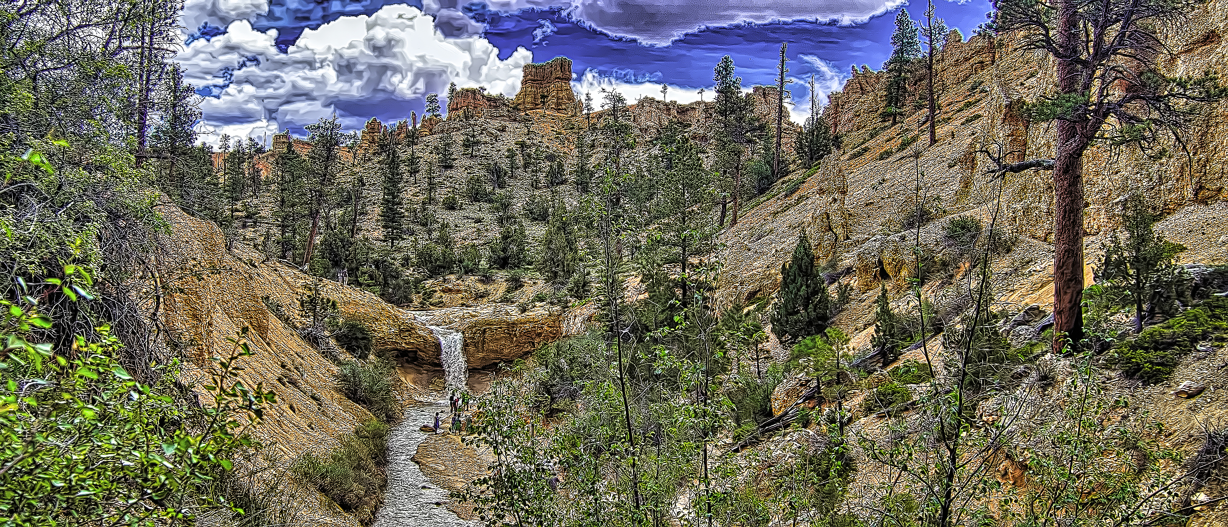
The next location along the highway is Bryce Canyon National Park. Of course we had just spent two days there so we drove by the entrance. However, there was one other location in the national park that we hadn’t visited. It was off of Highway 12 past the main park entrance. The area is known as Mossy Cave.
Because of the small parking lot, we needed to park at an overflow area and walk back. It is a short hike up into the nearby hills. On the surrounding hills are a number of rock formations including hoodoos. We could enjoy them as we walked the trail which ran along a river.


The site actually has two places to visit. One is the Mossy Cave, and that was not particularly impressive. It was more of an overhang where water dripped down. There was a limited amount of moss so not too exciting.

The more interesting element was the nearby waterfall and river. While the waterfall was not particularly high, it was powerful as the stream narrowed and gushed out through the narrow opening. The water itself seemed to have a light green tint to it. All in all the waterfall and the river itself created beautiful additions to the hoodoos in the area.


Returning to our car, we continued on Highway 12. While we were at Mossy Cave, we heard thunder. Shortly after we hit the road it started to rain. We hadn’t anticipated any rain. We came to the town of Tropic and saw a coffee shop so we stopped for a warm drink as it continued to rain. By the time we left, the rain had stopped.
One of the reasons I wanted to go on Highway 12 was to pass through the Grand Staircase-Escalante National Monument. This is a large area that has a wide variety of terrains. There are a number of interesting sites to visit in this national monument, but most of them are quite a distance off of Highway 12. We stuck to the highway and the large number of scenic vista points that we came across.
The beginning of the monument was in a rather desert type of environment. There were quite a few large rock formations. However, here it was not the red rock. The color was a light color, but the formations were pretty much the kind of thing we had seen in places like southern Colorado.


The highway began to follow a wide river bed. However, the riverbed only had a small amount of water running through it. We then came to a section of gray mound-like formations. To me they looked like piles of rounded mud. It was interesting, but it was not the most beautiful section of the drive. We did reach an overlook that scanned a large section of this gray area. However, at the top we could see a band of red around the top of a nearby butte.


As we continued on, the cliffs began to show some red in them again. The cliffs were often in layers with trees growing along the edges. We also continued to see riverbeds in places, but there didn’t seem to be a lot of water in any of them.


We passed through the town of Escalante. I had expected the town to be larger as it seemed to be a major center of activity in the area. However, it was not very lively at all. It was quite interesting to me that so far on this drive the highway had been pretty quiet. I expected that it being a scenic route, it would be fairly busy, especially on a weekend. However, such was not the case, which may explain how quiet the town was.
Shortly after leaving Escalante, we reached a viewpoint where we could look out over a large area and see some of the distant mountains. However, the haziness of the day made the distant points not very sharp. One of the interesting things to see from this viewpoint was the road. It was a major construction project President Roosevelt initiated with men in the Civilian Conservation Corps. This portion of the highway is called the Million Dollar Road.


Having looked down on the road, we then drove it stopping at an overlook of the Escalante River. It was obvious where the river was flowing as the trees clustered together along the river banks.


After driving down into the river basin, we went through some colorful canyons as we drove up out of the river valley. We stopped at a recreational area to try to get pictures of the canyon type walls. People were staying in a campground down below, and there was a nearby hike to a waterfall. Unfortunately it was three miles in, and we knew we didn’t have time to see it.


Driving farther up, we could look down and see the narrow canyons with the trees growing in them. I pulled to the side of the road for some photos and took a short hike over a hill to get a better view. I was surprised and excited to see a cactus plant with two pink flowers blooming, an unexpected treat in this desert environment.


After my side trip we came to an official overlook point where we could better see the canyon continue farther on across the landscape.


Boulder was the next community we passed through. As we were coming down into the town, I stopped to take some photos of the natural terrain as well as the areas where they had planted fields and created a green valley.


Coming out of Boulder, the green landscape continued in the entire scenery. We began to see evergreen trees, particularly pine trees. We were passing through the eastern portion of Dixie National Forest. Besides pine trees we began to see aspen trees growing in places along the side of the highway. The pines and the aspens seemed to compete with each other. There were a few places where they seemed to coexists, but then one or the other would start to dominate the scenery.


By now the viewpoints began to face east toward Capitol Reef. We saw distant cliffs and red rocks again, but now the colors seemed redder than the colors around Bryce Canyon. At these elevations the aspens were definitely the dominate tree.
However, at the next scenic viewpoint the smaller scrub evergreen trees began to dominate the landscape. We could see more of the cliffs and even saw a lake in the distance. We anticipated getting a closer look at some of the formations and cliffs of Capitol Reef National Park the next day.


The variety of terrains along Highway 12 makes it a unique and scenic drive. The final miles of the highway were only completed in 1985 so in many ways that part is a fairly new connection. The highway ends in the small town of Torrey which is where we were staying for the night. Check back next week as I share about our experience in Capitol Reef National Park.
.
Discover more from Battered Suitcase
Subscribe to get the latest posts sent to your email.