There are many ways to get to Oregon from Washington state. From Seattle, the obvious way is to head south on I-5. However, for this trip we were headed to Northeastern Oregon, and I decided we should go the scenic route over White Pass.

Crossing the Cascade Mountain range, which runs north and south through Washington, is necessary if one wants to travel east. The main Washington route is I-90 which takes one all the way to Boston if one so desires. There are other more scenic routes to take, however. Last fall we went over Stevens Pass to Leavenworth which is north of I-90. For this trip we traveled south to cross over White Pass.
The road to White Pass begins off of I-5 just south of Chehalis, Washington. At the beginning of the drive a sign welcomes drivers to the White Pass Byway. Hwy 12 is the actual highway name. It will eventually take travelers to Yakima.
We didn’t stop much at the west end of the drive. Unfortunately the weather was rainy with low clouds which obscured much of the surrounding hillsides. There are a couple of lakes one can view from the highway, but again visibility was difficult. We stopped at a viewpoint for Riffe Lake which is formed by the Mossyrock dam. However, the photos I was able to get were very foggy.


The next place we stopped was a view of cliffs with vertical rock strata called the Palisades. The viewpoint has some some picnic tables as well as the viewpoints of the rock. My only frustration is that new trees were growing in front of the viewpoint which blocks some of the view of these cliffs. Since they are new trees, it seems cutting them down would enhance the enjoyment of this location.


Hwy 12 offers other options beside just the White Pass Byway. One can go south and visit parts of the Mt. St. Helens Monument. Travelers can also go north from the highway and visit Mt. Rainier National Park, Just remember that this year Mt. Rainier has instituted timed entries to reduce crowding so make sure you check the website for information in regards to when those timed reservations are needed.
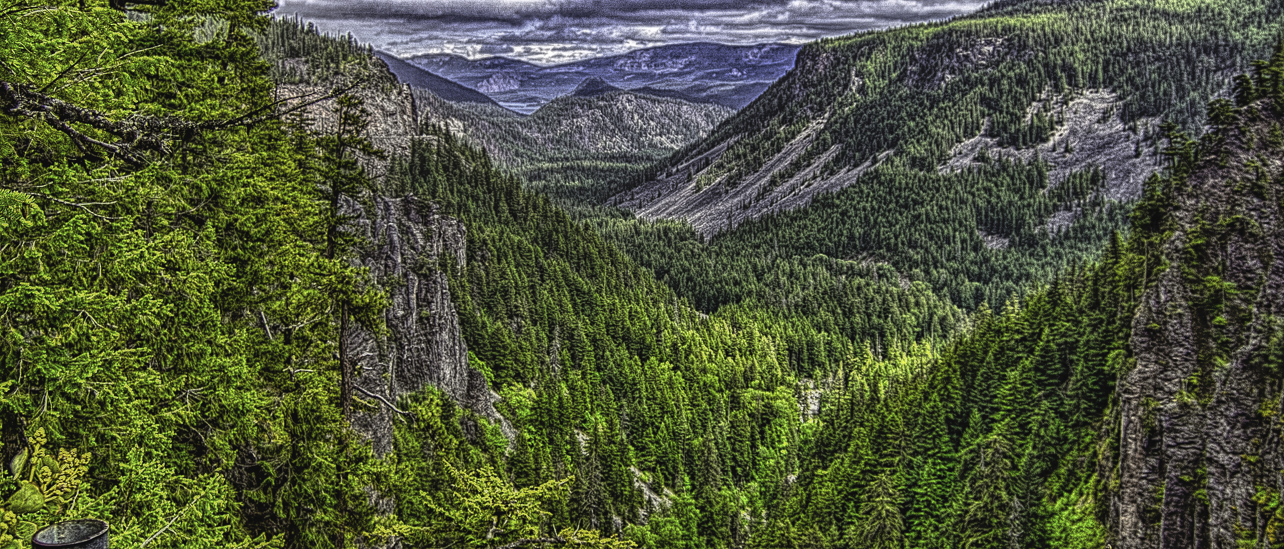
Farther along the White Pass Byway travelers come to Clear Falls. One can hear the falls before it can be seen. The falls is a little difficult to see since it is actually below the viewpoint so getting the right angle to see it all can be a bit challenging. There are a number of paths in the viewpoint that allow one to check out the views.


At the eastern point of the viewpoint, visitors can look quite a ways down the canyon to a lake just visible below. I believe it is Rimrock Lake which we will come to in a little bit. I also observed some interesting flowers here that were coming from grass. Not sure what they are.


It didn’t seem like it took long to drive down to Rimrock Lake. We made two stops here. The first was at Silver Beach Resort which was a private campground. I parked up by their store and walked down to the beach. It was a nice view to the western end of the lake but not the most spectacular view.


Next we stopped farther east on the lake at a day use spot. The views east here were better. However the wind was quite extreme. While it was not a particularly cold day outside, the wind really had a chilling effect when we left our car.


As we drove farther east we really began to realize we were in Eastern Washington. The hillsides became brown in many places, and there were various outcroppings of rocks in unique forms. We also began to follow the Tieton River. As always I like to find a spot to get out and take photos of a river. I found two spots. The first location had a number of rocks in the water which always add interest to a photo.


The second place we stopped was interesting in that the river divided around a small island in the middle of the river. What made it most interesting was a bridge had been placed across the river. It was a most unusual bridge. It was basically a long box. There were no railings to protect you at all, just the box to walk on. I saw one couple walk across it with no difficulty. My concern was that I would lose my balance due to the winds that were still gusting so we didn’t try to cross the river.


I found the mountain terrain very interesting and took some photos of the hills along the highway.


The Byway ends before one reaches Naches, Washington which is outside Yakima. However, Yakima was not our final destination for the day. We still needed to get to Oregon. We stopped near Yakima to get gas and some dinner and then continued south on Hwy 97. I had never been on this road before.
Shortly after we left Yakima, a sign announced that we were in Yakima Native American land. Agriculture seemed to be the main thing here, and we saw some orchards with cherry trees full of red cherries that looked ready to pick.
We drove through Wapato and Toppenish. As we arrived in Toppenish we saw the large Yakima Nation Museum and Cultural Center. When we drove by, it was closed for the day, but it looked like it would be an interesting place to visit and learn about the Yakima peoples.
From Toppenish the highway turns somewhat west. The first part of the drive crosses over the yellow colored hills with very few trees. It has a desert like quality to it. It is easy to see where streams and creeks are located, as it is only there one can see trees of any size.
The farther south one travels things begin to become more green and soon the road seems to be in a mountain forest with evergreen trees all around. The change is quite surprising.
This lead us into the town of Goldendale. Here the landscape begins to become brown again and dotted with a new feature, windmills. Windmill farms have become common across the US and having experienced the wind in this area, it seems a perfect location for a windmill farm.
We stopped at a viewpoint to discover that we couldn’t see anything. From the viewpoint one is supposed to see four mountains, Hood in Oregon, St, Helens, Adams, and Rainier in Washington. However, because the clouds we had escaped were still lingering over the mountains, we saw none of them.
We now headed south to the Columbia River. One last photo stop in Washington showed the cliffs on the other side of the Columbia as well as the Washington landscape. We then crossed the bridge into Oregon. This was our day’s destination, Biggs Junction which is just across the border.


After getting our things inside, we walked east along the Columbia River some. It continued to be windy, but we were glad to get a little bit of exercise before settling in for the night. It was getting dark, but I still managed a few photos.


Having crossed into Oregon we would now begin exploring the northeastern part of the state. Join me in a few weeks as we begin exploring this unique part of Oregon. In the meantime I am out of the country. Look for the next post soon.
Discover more from Battered Suitcase
Subscribe to get the latest posts sent to your email.