After spending a day at Great Sand Dunes National Park, it was time to head to our next destination, Mesa Verde National Park. From our stay in Alamosa we would travel across the southwestern part of Colorado along Hwy. 160. It would take most of the day as we stopped from time to time to see the sights.
We spent two nights in Alamosa. The town itself is really the nearest town for those planning to visit the Great Sand Dunes so the town has geared itself for tourists. Alamosa is the main city in the San Luis Valley. It was founded in 1878 and became an important city as the railroad lines traveled in all directions from it.
A walk down the main street today reveals that the town is trying to attract tourists with an appeal to art among other things. On many of the corners in the main part of town art pieces have been set up. The artists show a variety of interests and styles. It’s fun to look over all the pieces. The photos below are just a sampling of the artistic endeavors.


Main street also has both old and new buildings. A number of architectural styles are used in the downtown buildings as well as in the churches. One church I saw seemed to be abandoned. Another was a monastery, but has been converted to a restaurant with the unique name of The Friar’s Fork.


I had looked over our route along Hwy. 160 and settled on some places I wanted to check out. After we left Alamosa, the first town we came to was Monte Vista. This was not a place I had considered stopping to visit, but as we drove through the town, I wished I had. There were a number of old buildings that looked quite interesting as well as some shops.
One of the stand out things was the many cutouts of sandhill cranes that graced the town’s sidewalks. Just south of Monte Vista is one of three wildlife refuges in the area, Monte Vista National Wildlife Refuge. One of the main activities at these refuges is the migration of the sandhill crane. They start arriving on their northern journey in mid February, and have all gone by April. They return in mid-September, and are all gone by mid-November. Apparently there are hundreds of them, and they are quite a sight to see. So the town of Monte Vista has taken this bird as their own and used its image in creative ways.
After passing through Monte Vista, things were a little dull on the drive. In the valley we saw mostly farmland, and it was pretty flat. However, once we began to climb into the mountains, things became a lot more interesting. We began to follow along the South Fork of the Rio Grande River. Of course I wanted to take a picture of it. At the first stop, I couldn’t get too close. However, at the second stop I was able to get down near the river. The water flowed with tremendous force through the river bed. If someone fell into the water, I’m not sure they would have been able to save themselves. The current was that strong. Next to the river we saw tall cliffs of rugged rock. It was really a lovely location.


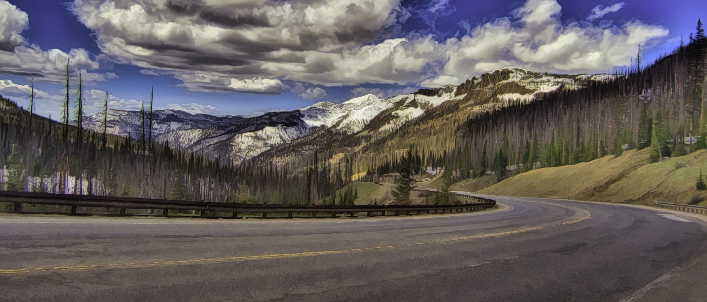
Climbing higher we began to see more snow on the tops of mountains. As we passed over the summit at Wolf Creek Pass, we came to a viewpoint that allowed us to take photos of the valley below and the hills surrounding it. Directly below this viewpoint were a lot of rough rock formations which provided interesting pictures.


From Wolf Creek Pass Hwy. 160 makes its way into the valley and the town of Pagosa Springs. This was a town I wanted to stop and visit. We ended up stopping at the east end of town. We read about a River walk along the San Juan River so we thought we would explore that. It didn’t go that far. However, it did show us a better map of the town, and we realized the main area we wanted to visit was farther west.


We walked over to the area indicated as the historic area. While we passed some typical shops and old churches, it wasn’t that exciting. We decided we were still in the wrong place. We eventually found the visitor center, and they steered us to the right place.


The reason for the name of the town is a deep water spring that brings up water with various minerals in it. Pagosa Springs developed around spas and baths that catered to people wanting to find the healing aspects of the water.
We were directed to the mother spring which is said to be the deepest such spring in the United States. It looks like a small volcano with multi colored streaks down its side. One can see the water flowing out of the top. One can also smell the sulpher smell. It reminded me somewhat of Yellowstone.
We walked across a bridge to the other side of the river. From there we could see the various tubs and flows of the water. While there are some fancy spas there, it is possible to just pay a fee and sit in the water. We also saw a few places where people seemed to be getting the water outside of this pay area along side the river. All in all it was a unique and fascinating place.


From Pagosa Springs we continued on Hwy. 160 as it passed over some mountains again. Along the way we passed by the Chimney Rock National Monument. Unfortunately the monument was closed, but we could still see Chimney Rock from the highway so we didn’t miss out entirely.
We eventually arrived in the city of Durango. Durango was much larger than I had anticipated. The outskirts of the city stretch quite a ways along Hwy 160. It seemed to take a long time to get to the city core and the historic center of the town.
The historic center really is full of old buildings. We walked quite a few blocks and saw old buildings in a variety of styles. A lot of shops and restaurants lined the streets. Even though it was a Wednesday afternoon, the streets were fairly busy with people walking around. It’s possible many of them were tourists, of course, but the businesses seemed to be doing well. One popular local feature is a steam railroad that takes visitors on a five hour plus ride into the nearby canyons.


Durango considers itself to be an outdoors center with a variety of sports available in the nearby mountains. Skiing, hiking and rafting are a few of the major activities in the area. The city boasts about having 300 days of sunshine in a year, but they also average about six feet of snow in the winter. Sunshine doesn’t always mean warmth. However, we enjoyed wandering around the town and its beautiful setting.
One more stop along Hwy. 160 is the town of Mancos. This is the smallest of the towns, but it has a reputation as a town of artists. They have a number of art galleries which display a wide variety of styles and mediums. A number of old historic buildings can be seen in the main town center as well as a brand new complex they are finishing up. We didn’t stay long in town, but enjoyed its charm.


We finally reached our destination of Cortez. Along the way we passed the entrance to Mesa Verde National Park. We will be returning later to explore what it has to offer us.
We enjoyed both the natural wonders and beauty along the highway and the interesting towns we visited. Do you have a favorite road you enjoy driving either for its scenery or its towns along the way. Be sure to share that in the comment box below. In the meantime, keep traveling.
Discover more from Battered Suitcase
Subscribe to get the latest posts sent to your email.
We were there in late June, Mesa Verde was amazing. We wanted to do the steam train ride to Silverton but needed reservation for the next day. Instead, we drove to silverton and on north over 13,000 foot pass and down to Montrose so we saw the beautiful pass without the smoke from the train.
Les, thanks for sharing your experience. I’ll be sharing about our experience at Mesa Verde in a few weeks.